
Talaksan:Political Map of the Arctic.pdf
Size of this JPG preview of this PDF file: 786 x 600 na pixel. Ibang mga resolusyon: 315 x 240 na pixel | 629 x 480 na pixel | 1,007 x 768 na pixel | 1,280 x 977 na pixel | 2,560 x 1,953 na pixel | 4,770 x 3,639 na pixel.
Buong resolusyon ((4,770 × 3,639 pixel, laki ng talaksan: 11.48 MB, uri ng MIME: application/pdf))
|
|
Ito ay isang talaksan mula sa Wikimedia Commons. Makikita sa ibaba ang impormasyon mula sa pahina ng paglalarawan nito roon. |
Buod
| Paglalarawan |
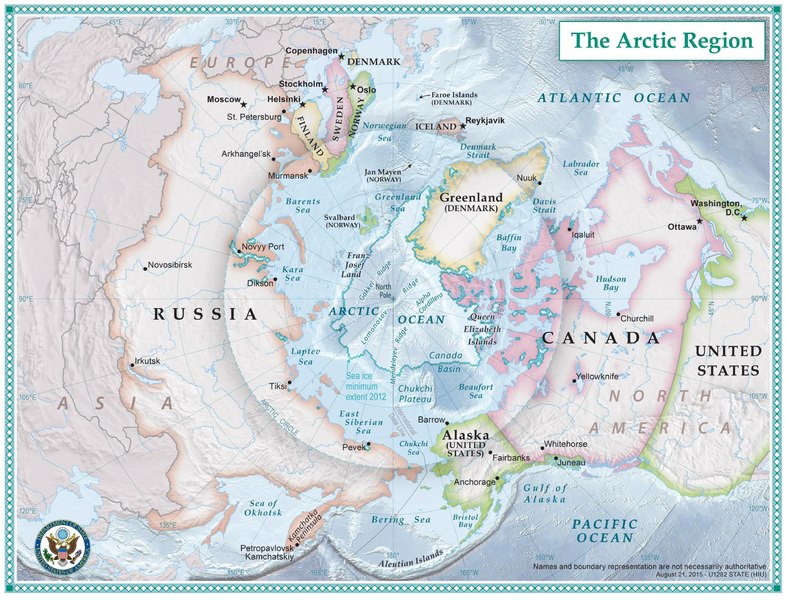
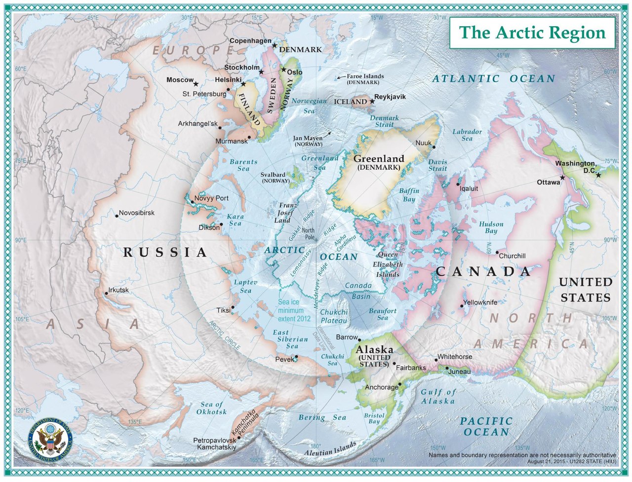
English: The nations which comprise the Arctic region. |
| Petsa | circa 2014 |
| Pinanggalingan | https://2009-2017.state.gov/e/oes/ocns/opa/arc/uschair/258202.htm . This map of the Arctic was created by State Department geographers as part of the U.S. Chairmanship of the Arctic Council. |
| May-akda | U.S. State Department |
Paglilisensiya
This work is in the public domain in the United States because it is a work prepared by an officer or employee of the United States Government as part of that person’s official duties under the terms of Title 17, Chapter 1, Section 105 of the US Code.
Note: This only applies to original works of the Federal Government and not to the work of any individual U.S. state, territory, commonwealth, county, municipality, or any other subdivision. This template also does not apply to postage stamp designs published by the United States Postal Service since 1978. (See § 313.6(C)(1) of Compendium of U.S. Copyright Office Practices). It also does not apply to certain US coins; see The US Mint Terms of Use.
|
 | |
| Nakilala ang talaksan bilang malaya mula sa nalalamang mga paghahangga sa ilalim ng batas sa karapatang-ari, kasama ang lahat ng mga kaugnay at karatig na mga karapatan. | ||
Nakaraan ng file
Pindutin ang araw/oras upang makita kung papaano ang itsura ng talaksan noong oras na iyon.
| Araw/Oras | Thumbnail | Mga dimensiyon | tagagamit | Kumento | |
|---|---|---|---|---|---|
| ngayon | 18:16, 24 Setyembre 2016 |  | 4,770 × 3,639 (11.48 MB) | Association Chemist | User created page with UploadWizard |
Mga ugnay
Nakaturo sa talaksan na ito ang mga sumusunod na mga pahina:
Pandaigdigang paggamit sa file
Ginagamit ng mga sumusunod na wiki ang file na ito:
- Paggamit sa af.wikipedia.org
- Paggamit sa ar.wikipedia.org
- Paggamit sa bn.wikipedia.org
- Paggamit sa en.wikipedia.org
- Paggamit sa fa.wikipedia.org
- Paggamit sa fr.wikipedia.org
- Paggamit sa ha.wikipedia.org
- Paggamit sa hr.wikipedia.org
- Paggamit sa hy.wikipedia.org
- Paggamit sa id.wikipedia.org
- Paggamit sa ja.wikipedia.org
- Paggamit sa mg.wikipedia.org
- Paggamit sa nds-nl.wikipedia.org
- Paggamit sa te.wikipedia.org
- Paggamit sa th.wikipedia.org