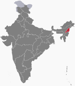
Nagaland
Itsura
Nagaland | |
|---|---|
 Nagaland -The Land of Naga Tribes | |
 | |
| Mga koordinado (Kohima): 25°40′N 94°07′E / 25.67°N 94.12°E | |
| Country | |
| Formation | 1 December 1963† |
| Capital | Kohima |
| Largest city | Dimapur |
| Districts | 11 |
| Pamahalaan | |
| • Governor | Padmanabha Acharya |
| • Chief Minister and Deputy Chief Minister | Neiphiu Rio (NDPP)[1] and Yanthungo Patton (BJP)[2] |
| • Legislature | Unicameral (60 seats) |
| • Parliamentary constituency | Rajya Sabha 1 Lok Sabha 1 |
| • High Court | Guwahati High Court - Kohima Bench |
| Lawak | |
| • Kabuuan | 16,579 km2 (6,401 milya kuwadrado) |
| Ranggo sa lawak | 26th |
| Populasyon (2011) | |
| • Kabuuan | 1,980,602 |
| • Ranggo | 25th |
| • Kapal | 119/km2 (310/milya kuwadrado) |
| Sona ng oras | UTC+05:30 (IST) |
| PIN | 797115 - 798620[3] |
| Kodigo ng ISO 3166 | IN-NL |
| HDI | |
| HDI rank | 4th (2005) |
| Literacy | 80.11% (15th) |
| Official language | English |
| Websayt | nagaland.gov.in/ |
| †It was carved out from the state of Assam by the State of Nagaland Act, 1962 | |
| Bird | Blyth's tragopan (Tragopan blythii) |
|---|---|
| Flower | Rhododendron |
| Tree | Alder |
Ang Nagaland /ˈnɑːɡəlænd/ ay isang estado ng India. Ito ay pinalilibutan ng Assam sa kanluran, Arunachal Pradesh at Assam sa hilaga.
Mga sanggunian
[baguhin | baguhin ang wikitext]- ↑ "Neiphiu Rio sworn in as Nagaland Chief Minister, becomes 1st Nagaland leader to take oath outside Raj Bhavan". The New Indian Express. 8 Marso 2018.
{{cite news}}: CS1 maint: date auto-translated (link) - ↑ "BJP to get deputy CM post in Nagaland". Times of India. 6 Marso 2018.
{{cite news}}: CS1 maint: date auto-translated (link) - ↑ "Nagaland Pincode". pincodeind.com. Inarkibo mula sa orihinal noong 2017-09-01. Nakuha noong 2018-03-25.
{{cite web}}: Italic or bold markup not allowed in:|publisher=(tulong)CS1 maint: date auto-translated (link) Naka-arkibo 2017-09-01 sa Wayback Machine.
